Động Phong Nha 
|
Khám phá Việt Nam - Động Phong Nha |
Khám phá Việt Nam - Động Phong Nha |
Động Phong Nha - Phần 1 |
Động Phong Nha - Phần 2 |
Clip thăm động Phong Nha |
|
Tổng quan
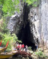
Thuộc vùng núi đá vôi Kẻ Bàng, xã Sơn Trạch, huyện Bố Trạch, tỉnh Quảng Bình, cách thành phố Đồng Hới 60km, động Phong Nha được coi là "Thiên Nam đệ nhất động" của Việt Nam.
Ðộng Phong Nha có rất nhiều nhánh với tổng chiều dài lên đến khoảng 20km nhưng hiện nay người ta mới khám phá nhánh dài nhất, là một phần của con sông ngầm có tên là Nậm Aki mà sông Son là phần lộ ra mặt đất. Nó chui ngầm dưới đất ở vùng núi Pu-Pha-Ðam cách đó hơn 20km về phía nam. Trước cửa động, cảnh núi non sông nước quyến rũ, thiên nhiên hùng vĩ với vô vàn hình ảnh kỳ thú hiện ra như khêu gợi trí tưởng tượng của con người.
Vào mùa nước lớn, nước sông Son dâng cao che khuất cửa hang, thuyền du lịch không vào đây được. Tương truyền hơn một trăm năm về trước, ông vua trẻ Hàm Nghi đã ẩn mình ở đây cùng một số cận thần và ra lời kêu gọi Cần Vương. Cửa động rộng khoảng 20m, cao 10m, có nhũ đá lô nhô. Bơi thuyền qua cửa hang, động rộng như một cái bát úp trên mặt nước. Nước sông trong veo và phẳng lặng như mặt gương, càng vào sâu ánh sáng càng nhạt dần rồi mất hẳn.
Xen lẫn với tiếng mái chèo như có tiếng chiêng vẳng lên. Người bản địa cho rằng đó là âm nhạc trong tiệc riệu của Thần Núi vọng ra... Tất cả hợp thành tiếng nhạc, lúc âm u như tiếng chiêng, lúc bập bùng như tiếng trống.
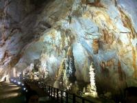
Phong Nha có trên 20 buồng với hành lang chính dài tới 1500m và nhiều hành lang phụ dài hàng trăm mét. Các hang ngoài cùng có trần cao hơn mặt nước rộng khoảng 10m. Các hang phía trong, từ hang thứ 4 trở vào trần hang cao đến 25-50m. Từ buồng thứ 14, du khách theo các hành lang khác đi sâu hơn nữa dưới mặt đất đến những buồng to hơn rộng hơn nhưng có phần nguy hiểm hơn, nơi mà quá trình phong hoá đá vôi vẫn còn tiếp tục.
Thuyền ngược dòng độ 800m thì đến chỗ cạn gọi là hang nước cạn do nước biến đi nhường chỗ cho đá cát. Nhũ đá từ trên rủ xuống, măng đá từ dưới nhô lên tua tủa như cây rừng với những hình dáng kỳ lạ. Khó có thể mô tả vẻ đẹp hùng vĩ của những buồng, những hành lang đá vôi phủ đầy thạch nhũ long lanh dưới ánh đuốc của dòng sông ngầm. Du khách vừa xúc động vừa ít nhiều hồi hộp lo sợ khi thấy mình như đang nằm trong miệng một con quái vật khổng lồ: với những hình thù kỳ dị nguyên sơ mà trí tưởng tượng của con người tha hồ gán cho chúng biết bao huyền thoại, sự tích.
Sau hàng chục cuộc thám sát khoa học của người Việt, người Pháp, người Anh... động Phong Nha vẫn còn đó với những điều bí ẩn.
Toạ độ
Bài viết
Bình luận
Lưu ý: chúng tôi không chịu trách nhiệm về nội dung các bình luận của bạn đọc
|

|
| Địa chỉ |
TL20, Son Trach, Bo Trach District, Quang Binh province, Vietnam |
| Thêm bởi |
admin |
| Vào ngày |
2012-11-04 23:59:11 |
| Các thành viên |
|

|
|

(186 m) |
(4.89 km) |
(10.05 km) |

(13.94 km) |

(16.26 km) |

(22.31 km) |

(25.45 km) |
(38.20 km) |
|