Discover natural & cultural heritage of Vietnam
English
|
Tiếng Việt
Landmarks
Images
Wiki
Login
Browse
Search for
in
Viet Nam
Landmarks
All
»
Viet Nam
»
Central Vietnam
»
Northern Central
»
Thanh Hoa
»
Đền Hổ Bái
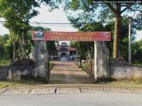
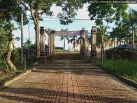
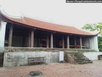
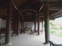
Đền Hổ Bái
Overview
Location
Retrieving
Find direction to this place
Weather forecast
Show on Wikimapia.org
Images
[full view]
[Google Images]
©
den ho bai (1)_txt
Image
by
vietlandmarks.com
©
den ho bai (2)_txt
Image
by
vietlandmarks.com
©
den ho bai (3)_txt
Image
by
vietlandmarks.com
©
den ho bai (4)_txt
Image
by
vietlandmarks.com
©
den ho bai (5)_txt
Image
by
vietlandmarks.com
©
den ho bai (6)_txt
Image
by
vietlandmarks.com
©
den ho bai (7)_txt
Image
by
vietlandmarks.com
©
den ho bai (8)_txt
Image
by
vietlandmarks.com
©
den ho bai (9)_txt
Image
by
vietlandmarks.com
Insight
References
[Google search]
Comments
Note: we are not responsible for the comments posted by users
Đền Hổ Bái
@20°0´36”N, 105°34´22”E
Address
Added by
admin
Added on
2025-03-09 03:58:30
Members
admin
(admin)
Current weather
...
Nearest places
Đền thờ Thái sư Á Vương Đào Cam Mộc
(2.31 km)
Động Hồ Công
(4.08 km)
Tomb of lord Trinh Sam
(5.62 km)
Đền thờ vua Lê Đại Hành
(5.68 km)
Nhà cổ di sản UNESCO
(7.64 km)
Citadel of the Ho dynasty
(7.85 km)
Lăng mẹ vua Lê Huyền Tông
(11.71 km)
Phủ Trịnh
(11.76 km)